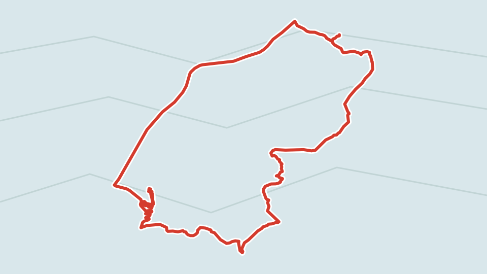
The next morning I had breakfast thanks to the kindness of Vartan, who left me some food, and rolled around the surroundings of Sde Boker, thanks to the kindness of Mike and his friend, who had put together a route for me.
In the morning I quickly dropped by the grave of Ben Gurion and his wife, took a look at what the college town looks like in the light of day, and off I went.

Wild animals roam around, but since they are allowed everything, they aren't afraid of humans at all


Studying Israel and Zionism

They swiped the “Snowdrop” logo!
I descended into the Tsin Valley down an asphalt switchback. Now with video blogging!
Download mp4 video

Here it is, the valley itself

A campsite down below, rules in three languages

The road starts off very decently

But gradually we realize why it's only allowed for off-road vehicles

Because in places it runs right along the dried-up riverbed

With such a gradient you have to work up a sweat, but the best is yet to come!

Reminds me of Iceland in places, only the colors are different, and there are more rocks
When we were exchanging phrases the night before with Vartan's buddy Brian, he wondered, why Israel specifically?
I was asked this question countless times: both there and here, by old and young, by friends and brothers. The answer finally crystallized only while visiting Vartan.
Sometimes, minor coincidences, signs and omens converge, and life itself steers you onto the right path. First, my mom's friend from Israel came to visit and invited me over, then I found a cheap plane ticket, and then I learned that a third of the country is a desert popular with rugged tourists. I realized that Israel is somewhat similar to the Iceland I've grown so fond of — with the difficulty of growing edible organics, with the strong character of people who, for the sake of their dream of an independent life, are ready to fight harsh nature to the bitter end. Icelanders, too, had to fight their neighbors and endlessly defend their independence, which the country only gained in the twentieth century.
The Israeli desert is also very similar to the Icelandic tundra, only one lacks water, while the other lacks sun. In both places there are rocks, mountains, lots of nature, and few people, moreover because Iceland is small in population, and Israel is small in area. As for the inhabitants, here, of course, the similarities end — Icelanders are calm, unhurried, and goal-oriented, while the locals here are southerners, much more emotional and disorganized. Their motto, as Nathan told me on the first day, is “it'll all work out”.


A simple road (albeit a steep one) went up, but we don't need to go there, right?

Here is where we need to go — onto a hiking trail that's banned for bicycles

The beginning is quite tolerable

But pretty soon you have to ride on stone slabs

It's hard to even imagine what awaits ahead

It's hard on foot here, let alone on a bike
As a result of an ill-considered, and all the more interesting, decision to turn off, I, as you can see, got into such a mess that I had to lug the bike on my shoulders, in places at such an angle that I couldn't even walk up, and practically slid back down. It seems this was the exact trail Mike recommended for fans of technical extreme downhill, but he warned that a national park ranger with a fine ticket might be waiting at the end. I, true to my habit of not seeking an easy life, tackled the thing from the other end, and instead of a super complicated descent I wound up in an attraction long familiar to my readers: “lug the bike on your shoulders up mountain trails”. As a nice bonus, this time around there wasn't knee-deep snow, like in Montenegro, and no drizzling freezing rain, like in Iceland, but scorching heat and dry dust.

But what beauty!

Do you see a trail here? Yet there is one!

It's a good thing I was without my panniers. I'm afraid with the bags it would have taken me over an hour to walk up here

But here we are, the hardships are behind us

Wide open spaces lie ahead
Along the way I found out what the trail is called (from the sign). A wadi is a dried-up riverbed. Walking through a wadi in winter is quite a risky venture — if a downpour starts, the wadi will be flooded with muddy churning sludge that will sweep you forward, slamming you against the rocks.

But for now it's all easy

And beautiful

The “water holes” sign intrigued me, and out of my habit of never missing anything, I turned off

The holes are not bad, but the cave cities of Crimea are better, so I headed back

The park near Ben Gurion's grave

And the grave itself
It wasn't even noon yet when I returned to Midreshet Ben-Gurion. A curious detail: Hebrew is read from right to left (which gives a lot of headaches to IT guys), but I don't know how to read it, so I don't perceive the combinations of letters as words. And therefore, if you look from left to right out of habit, it seems like the date of death comes first, and then the date of birth. It's as if Jews are all Benjamin Buttons to a man, or they left the pleasant event (birth) for later, the way some people save the tastiest part for last.
In the midreshet, by the way, is the Ben-Gurion National Solar Energy Center, and next to the town there is a huge field of experimental solar panels, with one of them looking like a massive radio telescope. Israel, as is widely known, exports not only weapons, a useful thing of course, but not a very pleasant one, but also a bunch of other high-tech stuff. In Israel there are tons of companies developing and selling solar panels and other types of equipment for "green" energy; the company Better Place originally hails from Israel, which tried to introduce electric cars with swappable batteries at gas stations, but went bust. As history teaches us, pioneers are far from always able to break through people's mindset and the status quo. But what didn't work out for Better Place is now working out perfectly for Tesla Motors.
On the other hand, the Intel Pentium M processor architecture also hails from Israel, which, if memory serves, served as the foundation for all modern Intel processors. Apparently, Intel's Israeli engineers got so fed up with the constant heat that even in processor development they started fighting it first and foremost, because the main feature of the Pentium M was lower power consumption and heat dissipation initially built right into its design.

A mysterious pipe, dumping sewage or what?

Farewell, Tsin Valley!
Over the morning I rode 31 km with an elevation gain of 400 meters. Not too shabby, and there's still the road to Mitzpe Ramon ahead.
The Tsin Valley was really to my liking. Finally, some real biking challenges began! After all, the goal wasn't just to hang around in Israel, but to bomb down winding trails on a bike. Up to this point the roads and views were decent, but still a bit boring. And here at last — a jagged switchback, an insane gradient, small rocks and huge boulders, breathtaking lunar landscapes — everything we love so much about mountain bike touring.